A Trip to Town from CPT International: the Cooling Towers (2/5)
Visiting Cape Town soon? Here’s a sneak preview of your first glimpses of the city – what you’ll see en route from the airport to town (click on the CPT to Town tag for all the posts).
Proceeding along the N2, you continue to pass the city’s outlying townships, until you see, rearing up on the horizon, two enormous cooling towers that appear to be in some state of disrepair, and your heart momentarily leaps into your throat.
.flickr-photo { }
.flickr-frame { float: left; text-align: center; margin-right: 15px; margin-bottom: 15px; }
.flickr-caption { font-size: 0.8em; margin-top: 0px; }
.flickr-frame { float: left; text-align: center; margin-right: 15px; margin-bottom: 15px; }
.flickr-caption { font-size: 0.8em; margin-top: 0px; }
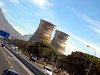
Relax! They’re not nuclear: they’re the cooling towers of the now-defunct but once coal-fired Athlone Power Station. The power station was mis-named, for it’s actually in the backyard of Langa, Cape Town’s first “black,” or “African” township.
Where are you? You’re at – or have just passed – the junction of Bhunga Avenue and the N2 highway.
What are you seeing? On your right, Langa township, which, at over 100 years old, is the city’s oldest “black” or “African” township. On your left, the “Coloured” townships of Silvertown, Bridgetown and Athlone.
What should you know? Apartheid’s planners were, unfortunately, quite successful in their aims of dividing the city’s population. Highways, railways, canals, and industrial areas were used, not just for their primary purposes, but also as “buffers” separating the people classified in the various racial groups. It’s practically impossible, for instance, to get from Langa to Athlone in a straightforward manner. (Look at the map above; you’ll see that Bhunga Avenue only provides access to and from the N2, but does not extend into the residential areas on the other side of the N2. Town planning was quite twisted under apartheid.)
.flickr-photo { }
.flickr-frame { float: left; text-align: center; margin-right: 15px; margin-bottom: 15px; }
.flickr-caption { font-size: 0.8em; margin-top: 0px; }
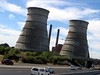
The cooling towers, meanwhile, have been out of commission since the 1990s. Various proposals have been made for their “rehabilitation” – my favorite: turn them into a cultural museum! – but for now their primary function is simply to rust.
How can you visit? The Direct Action Centre for Peace and Memory has an excellent “geography of apartheid” tour that centers on the cooling towers, using them as an alternative landmark to Table Mountain for navigating around the Cape Flats.